sri lanka part 2: arugam bay

I love a good routine. Traveling is amazing, and the depth and breadth of experiences I’ve had have been life-changing. But with all of the “go go go” traveling I’ve been doing lately, I was craving some relaxation, and yes, routine. And Arugam Bay was the perfect place for it. Arugam is world-famous for its surfing, and I took advantage. I surfed every day (sometimes twice a day), living out my pre-teen dream of being a “surfer chic.” I also did yoga everyday, which I had been seriously missing. It’s so much easier to live an active lifestyle when you’re not worried about where you’re going to sleep tomorrow!

On top of yoga and surfing, I also spent 2-3 hours every day at the Ayurveda doctor (Ayurveda is an ancient form of medicine that originated in India, and is still very popular throughout the region). I learned a bit about Ayurveda as part of my yoga program, and had found that Ayurvedic massages really helped my bum knee (both with the pain and stiffness). So I signed up for a week long program that included massages, herbal treatments, steam baths, and lots and lots of oil! Plus, a cleanse (which all that shatkarma in Rishikesh really helped prep me for).

After almost 2 weeks in Arugam, and on the final day of my treatment, Dr. Jahufer smeared a dark red herbal paste on both knees, wrapped them both tightly in bandages, and said, “No water for 3 days.” I had thought about going north up the coast to Trincomalee (another beach town), but I figured the 3 days of no swimming (or showering) would be better used in transit. So, going back the way I came, I took 3 buses from Arugam to Ella, and then the beautiful train ride between Ella and Kandy (and then another 6 hours or so of less exciting train ride from Kandy to Colombo), and finally the airport.

Here are a few more pictures of the train ride because it’s just that good…Kutpai for now Sri Lanka 🙂

sri lanka part 1: colombo & the central province

Sri Lanka is (quite literally) a breath of fresh air after India. Aside from its much appreciated cleanliness, the food is awesome, the people are super nice, and from the beach to the mountains, the views are pretty unbelievable. For my first week and a half (ish) in Sri Lanka, my route was: Colombo, Kandy, Matale (and Dambulla), back to Colombo, Kandy, and finally Ella (actually in the Uva province, right next to central). My route was definitely a little wonky, but the country is small, and the trains are (mostly) pretty fun! And definitely worth getting to spend the extra time with my friend Omar who flew in from Dubai to meet me 🙂

The central region of Sri Lanka was one of the greenest places I’ve ever been. It rained almost every day at least some, and I didn’t even mind because it felt even more rainforest/jungly. Another thing I noticed and loved was the diversity of religion. While the country is predominantly Buddhist, there are Hindu temples scattered (and often inside Buddhist temples), as well as Christian crosses, and prayers being sung out loudly from Muslim mosques.

Here are some highlights …

Colombo – Colombo gets a bad rap. Most people just say skip it, and a couple days was plenty for me. The main part of the city is extremely modern (the most “western” feeling place I’ve been in Asia so far). I took a short train ride down to Mount Lavinia (actually I took an express train way past Mount Lavinia on accident and had to backtrack), which seems to be what most people recommend, and stayed near the beach. There are a ton of cute (but expensive) restaurants along the water, and it’s actually pretty nice!

Kandy – Loved it so much, I did it twice! (Kidding, sort of). Sri Lanka’s second biggest city, it is far less western and built up. It’s a cute little town, really green and hilly, with a big white Buddha overlooking the town and its lake. It’s home to a temple holding a tooth relic of the Buddha. We went during one of the daily ceremonies, and it was packed with an odd mixture of devout Buddhists making offerings and receiving blessings, and tourists elbowing each other for the best photo angle. My first visit we stayed a couple kilometers from the city center. In exchange for the cost of a tuk tuk into town every day, we had amazing views, a pool, and peace and quiet. My second time around I stayed right in the city in a tiny hostel. Both were good, very different experiences. Other highlights include a walk through Udawatta Kele Sanctuary with an awesome view of the city from high up on a hill, and the mango juice at the Kandyan Muslim Hotel.

Matale – The train ride from Kandy to Matale was a highlight. We took a local commuter train, and it was slow enough for us to (semi-)safely ride hanging out of the carriage doors. It was so fun, and so green. On a day trip, we went north to Dambulla to visit the giant Golden Buddha temple and cave temples. In the midst of hundreds of Buddhas, there was also one Hindu cave. And so many adorable, alien-esque baby monkeys. After visiting the Hindu Sri Muthumariamman Kovil temple back in Matale, we wandered into a hole in the wall restaurant for dinner and tried Kotthu for the first time. It’s basically rotti (flat round bread), chopped up and mixed with a bunch of veggies and spices. It’s amazing, and I ate it every day for quite a while after that.

The train from Kandy to Ella was a destination in itself. It’s famous for being beautiful, and it did not disappoint.

Ella – Ella is an adorable, very small town surrounded by tea covered hills. There are two main hikes you can do – Ella Rock and Little Adam’s Peak (it resembles the shape of the much larger and more famous Adam’s Peak, also in the central province). I went for the much easier Little Adam’s Peak (because my knees haven’t quite recovered from Everest yet), and walked for maybe 3 hours total through tea plantations with amazing views of Ella Rock. After my hike, I toured a green tea factory and learned about how the tea is made and the difference between the higher and lower quality varieties. That afternoon I took a short bus ride to the beautiful, but incredibly crowded Rawana Falls. I did all of my Ella “sights” in one day, but stayed for about 3 because it’s just a nice place.

Kotthu – a carb-lovers dream/my new favorite food…

image

More to come on the rest of my Sri Lanka journey 🙂


11 days in rajasthan

To me, Rajasthan is the India of India. The desert, the camels, the style, the food. It’s everything that is my romantic (western) notion of Inda. How and why I left myself only 11 days to experience this magical state I really can’t explain. But to my pleasant surprise, this 11 day itinerary actually kind of worked. Don’t get me wrong, I’d love to have had way more time here, and in no way encourage cramming all of the state into 11 days. But if you’re crunched for time like I was, here’s an itinerary that gave me a good taste of Rajasthan.

Agra –> Udaipur
Overnight train, 3rd class AC sleeper, about 1,200 rupees, 12 hours

I spent 3 days and 2 nights in Udaipur. A quiet (quiet for India) lakeside town, Udaipur is clearly made for tourists. Food and shopping was a bit on the expensive side, and in terms of sights there aren’t THAT many. I found Udaipur very relaxing, and enjoyed somewhat lazy days. A few activities I’d recommend: have an Ayurvedic massage (I paid 900 rupees for 70 minutes), take a yoga class, watch the sunset from City Palace (30 rupees to enter the sunset point, just south of the palace), and take and art class! The last was probably my favorite activity. I went to Ashok Arts and had a great experience! My instructor was patient and a good teacher. One of the shop employees read my palm as we all took a chai break. And 3 hours later, I had a one of a kind silk painting, that (imho) looks pretty legit 🙂

I stayed at Bunkyard Hostel, and highly recommend it. I met a lot of cool people, the facility is beautiful with a ton of open space, and it’s very centrally located. I paid 300 rupees per night for a bunk room.


Udaipur –> Jaisalmer
Overnight AC sleeper bus, 750 rupees, 13 hours

I spent 3 days in Jaisalmer, and 2 nights (including one sleeping under the stars in the desert!). Jaisalmer is easily one of my favorite places in India. This may be in part because I’m a born and raised desert girl, but to me there’s nothing better than a desert rain and sleeping under a black sky filled with stars, to the sound of crickets chirping. The skyline of Jaisalmer includes tan desert, tan buildings (including palace-like Havelis that rich families still live in), and the huge tan fort which rises high above the city. I spent one day just wandering around the fort, getting lost in alleyways and admiring the views. The highlight of Jaisalmer, though, was the overnight camel safari. We drove about 30 minutes out of the city and met our camels and guides. For 1,600 rupees we had 2 meals, our bed under the stars, and a few hours of camel riding in the afternoon/evening and the next morning. So much fun!


Jaisalmer –> Jodhpur
Non-AC bus, 350 rupees, 5 hours

I spent 2 days and 2 nights in Jodhpur (the 5 hour bus ride unfortunately took the better part of one of the days). I could have definitely stayed longer. The shopping is cheaper than anywhere else in Rajasthan; at Sardar Market you get the local experience and the local prices. I spent half a day just shopping – the clear highlight was M.V. Spices, one of the oldest spice shops in Jodhpur, and it’s run by all women! The spices come along with emailed recipes, and the best customer experience I’ve had in India. And it was totally reasonably priced, with 150 or 300 rupee bag options. There’s no reason to leave the market for food, as there is a ton of awesome street food. My favorite (not quite street food) was at Shri Mishralal Hotel, just inside the gate. They have one lassi option (the classic Rajasthan flavor) – Makhaniya, which is plain with saffron and cardamom (YUM), and an amazing Jodhpur specialty, Mirchi Bada, which is a pepper stuffed with potato and deep fried (double YUM).

The other major attraction is Mehrangarh Fort and museum. It cost 600 rupees to enter, and you have to purchase a museum ticket to get to the top. For a museum, it was pretty good. But the real reason to go is for the views of the blue city from the top.


Jodhpur –> Pushkar
AC bus, 450 rupees, 4 hours (the bus actually goes to Ajmer, but my hotel picked me up for free)

I only spent 2 days and 1 night in Pushkar, and that was enough for me. I bought awesome, funky, and most importantly fairly priced jewelry at Vikas Silver Walla. The shopping is definitely good in Pushkar, but a lot more expensive than in Jodhpur. I wished I’d bought the funky leather pointed slippers in Jodhpur, because they had way nicer and cheaper ones there. I skipped Brahma temple (the only Brahma temple in all of India), because the crowds were overwhelming. What I did not skip was Savitri temple. For 90 rupees a cable car takes you to the hilltop temple, and it was more than worth it for the views of all of Pushkar! Pushkar in general is a bit expensive, especially if you eat at the more “western”/tourist places, shop along the main road, etc. The best deal? Street cart lassis 🙂


Pushkar –> Jaipur
Cab from Pushkar to Ajmer train station, 400 rupees. Non-AC train to Jaipur, 2 hours, 250 rupees

I spent 1 day and 2 nights in Jaipur, and it was my least favorite of all of the cities I visited in Rajasthan. The Amber Fort was pretty spectacular, but Jaipur is a big city, and big cities in India come with an entire set of their own difficulties. Urban poverty was the most obvious here. The noise and traffic was the worst. And more than anywhere in India, I couldn’t walk more than 10 seconds anywhere without being yelled at by a shop owner, food cart guy, tuk tuk driver. I was more than happy that I only gave myself one day here. After a long day of sightseeing (exhausting!), the day was saved by an amazing hole in the wall restaurant right outside of my hostel (Zostel). The food was yummy, the people were nice, and best of all I walked to a nearby bakery afterward and ate a delicious, chewy, coconuty desert. I have no idea what it was called, but it was amazing.


Jaipur –> Delhi
AC train, 6 hours, $750 rupees

Rajasthan really exceeded my expectations in a lot of ways. There were times when it was really hard (like a lot of India), but the colors, the tastes, the scenery, the forts, the camels, the jewelry and the shoes and the textiles and the sarees… So much beauty crammed into 11 days 🙂

varanasi, the holy city (in the off-season)

After over a month in Nepal, I was so excited to go back to India. My first stop, Varanasi. When I shared my plans with people, literally the only response I got was, “Now? Don’t go there now.” I went anyway. Despite temperatures well over 100, and humidity upwards of 80%. Monsoon rains provided brief relief from the heat, in exchange for very flooded streets. Because tourism comes to a halt this time of year, only one of every three storefronts was even open. What doesn’t slow with the heat is death. Year round pilgrims come from all over India to send their loved ones to the afterlife on the holy river Ganges. To die in Varanasi is said to allow a person to reach moksha (or nirvana). If not to die, to be burned by the Ganges is beneficial, and some believe necessary, in sending a loved one to their next life. While tourists are few and far between, the fascinating rituals around death are as alive as ever.

Varanasi was really really cool. And as a bonus, I was able to meet up with two of my yoga friends from Rishikesh and Manali! Even in the summer, there’s a lot to do and learn in Varanasi. Below are some activities that filled our time. Some are more serious than others, but all are real things we did.

1.) A boat ride on the Ganges – we woke up for sunrise, but unfortunately cloud cover meant no sun.

2.) Every morning there is yoga at sunrise at Assi ghat – a fun procession of fire ceremony, singing and chanting, breathing exercises, and laughter yoga. And hundreds come out for it, young and old alike!

3.) Watch a cremation, usually many at a time, at one of the burning ghats.

4.) Have a lassi (or two) at Blue Lassi (still open even in off-season!). My favorite, and very unique flavor – mango cashew chocolate. Yum.

5.) Go into hotels that are clearly out of your budget and haggle for “off-season” deals. (haha)

6.) Watch how silk fabric is made on a traditional loom.

7.) Trek through the narrow streets during a rainstorm – knee deep in the dirtiest water you’ve possibly ever seen.

8.) Attend a fire ceremony at the main ghat – every night.

9.) Go to a Bollywood movie.

10.) Talk to people. You can’t stand or walk anywhere near the ghats without people coming to talk to you. Most are touts and will ask for money. But we talked to them anyway, and learned a lot! Here are some interesting tidbits about Varanasi, cremations, and the Hindu belief system around death.

  • Anywhere from 70-300 people are burned in Varanasi every day.
  • Six types of bodies are not burned: small children (because they are already innocent), pregnant women (same reason, innocence), people who die of leprosy (the smell of the corpse burning is too strong), animals (because of their place next to God), those who died of cobra bite (because of their potential to have second life if a healer finds the body), and holy men (because of their closeness to God). All of these types of bodies are wrapped with rocks, rowed to the middle of the river and sunk, except for the cobra bitten bodies – they are wrapped in banana tree leaves and floated down the river, hoping that a healer will find it and bring second life.
  • Women and children are not allowed at cremations because they are more likely to weep, and weeping doesn’t allow the deceased soul to leave its body.
  • Priests and holy people are burned on platforms high on the gat; on the river bank, the poorest people are closest to the water, middle and upper castes higher up on the bank.
  • In old times, wives were expected to jump onto their husbands burning bodies; if not, they were thrown on.
  • Cremations don’t smell bad at all because oily wood, like sandalwood, is used.
  • Cremations only last 3 hours, which usually leaves part of the hip bones of women, and chest bones of men – these along with the ashes are thrown into the Ganges.

Varanasi is one of the oldest continually inhabited end cities in the world, the 12th oldest. Its narrow, winding alleyways are famous for getting lost in. There are beautiful old temples around every corner. Cremations happen openly throughout the day, and you often see bodies wrapped in colorful cloth being carried through the streets by chanting family members. The introduction of motor vehicles and packaged foods means a lot of noise, and a lot of trash. But it’s a beautiful city, and its wealth of tradition and ritual made this an amazing city to visit, even in the off-season.

chitwan to varanasi in 22 hours

In my (almost) 3 months in India and Nepal, I’ve had some very intense travel days. Getting around India I spent up to 17 hours on local buses from place to place. But getting from Nepal to India overland was the longest travel day I’ve had yet. It included an overnight train, a tourist bus, 2 local buses, a shared cab, a tuk tuk, and a bicycle rickshaw. It also included a ~2 hour or so stop at Lumbini, Buddha’s birthplace. To my surprise, this was one of the easier and more enjoyable travel days I’ve had.

7:30am – left hostel in Chitwan to walk to the bus stand (a little over 20 minutes)

8:00am – arrived at bus stand for the 9:30am bus (this was unnecessarily early, since the bus wasn’t even there until 9; during on-season you’d buy your ticket ahead of time, but I had no problem buying on the bus when it arrived). 600 rupees.

9:30am – 2:00pm – bus ride from Chitwan to (near) Sonauli, a border crossing for Nepal/India (about 4.5 hours); compared to the bus ride into Chitwan, this one was much smoother. The ride in was so bumpy I was flying out of my seat every other minute. This bus ride was much more crowded, though, as it acted like a local bus. We stopped several times, letting locals on and off. The bus will filled almost the whole way. I’m so thankful it wasn’t too hot of a day, and an early rain cooled us off even more.

2:00pm – from where the bus let us off, I took a shared cab to Lumbini, which was about 20 minutes. I spent about an hour in Lumbini, I walked to the temple at Buddha’s birthplace, but decided not to go inside. It was 200 rupees entrance, and I was in a hurry because I’d left my backpack in a random travel booking office. The shared cab was 500 rupees 😦

4:00pm – took a local bus back to the bus stop for only 50 rupees (apparently this bus runs every half hour or so), then switched to another local bus to get to Sonauli, 15 rupees. About 30 minutes total.

4:30pm – arrived at border crossing, hired a bicycle rickshaw for 100 rupees to take me to the Nepal immigration office for my exit stamp, the India immigration office for my entrance stamp, and then to the bus stop. About 30 minutes total.

5:10pm – 8:20pm – local bus from Sonauli to the train station in Gorakhpur. About 3 hours, 97 rupees. When I arrived at the train station, I skipped all of the lines because I’m a tourist. I got one of the last two seats on the overnight train to Varanasi, and had to pay for 1st class. I was lucky because it’s off season in this part of India too, during on season you’d be extremely lucky to get a train ticket only a couple hours before departure I think. 

10:45pm – 4:45am – 1st class AC train from Gorakpur to Varanasi. The train station was extremely confusing. At around 10:40, I was still waiting for my train at the platform listed on my ticket and on the electronic departures board. I looked back at the opposite platform and noticed a tiny sign on the side that said “Varanasi.” For the next 5 minutes I ran frantically down almost the entire length of the train looking for my car. There were no conductors or train station employees. Luckily people were really helpful, even though almost no one spoke English, several people looked at my ticket and pointed me in the right direction. I finally found my car, and my sleeper bunk. I was exhausted and slept like a baby. Setting an alarm for 4:35 was absolutely necessary, as there were no announcements, the lights stayed off. I definitely would have slept until the end of the line (wherever that is). 1,160 rupees.

4:45am – arrived in Varanasi; it took about 10 minutes to walk out of the train station, and from there took an 80 rupee tuk tuk to my guesthouse.

5:30am – arrived at guesthouse!

Total time on the road from hotel to hotel was about 22 hours. The stop at Buddha’s birthplace was completely unnecessary, but I would have just spent the extra time at a bus and/or train station. I was really intimidated by all of the bus and train changes, but it was actually kind of nice to break up the trip that way. I got really lucky with the timing of all of the buses too, I never had to run after one, but I never had to wait that long either. All in all, not a bad travel day, and definitely not the miserable and confusing trip that I’d read about online.

pokhara & chitwan, nepal

My plan after Everest was to head straight back to India. But trekking for 2 weeks straight took a toll on me, and India is the opposite of relaxing. So I stayed for about 2 more weeks in Nepal, and I’m so happy I did. Pokhara, a lakeside hippie town, was the perfect place to do lots of nothing all day. The sunsets were gorgeous, scooters were pretty cheap to rent and easy to drive around as it wasn’t too busy there. And Himalayan Cafe had the best banana lassis I’ve tried yet. And Chitwan was beautiful, lush and green; I soaked in the flora and fauna knowing that the next 3 weeks in India were going to be filled with dirty cities and barren deserts.

There’s not really much to write about, and I was really bad about taking pictures. But here are a few lovely moments I captured. All I can say is that both Pokhara and Chitwan are absolute musts if you get the chance to visit Nepal. (And for the record, I don’t recommend Kathmandu other than as a jumping off point for trekking the Everest region, it’s just another dirty, busy city).

pokhara

chitwan


breathtaking views at breathtaking altitude: everest base camp and kala patthar

DCIM100GOPRO
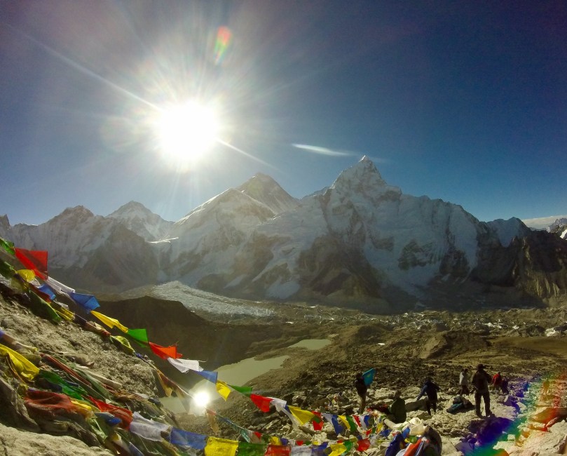
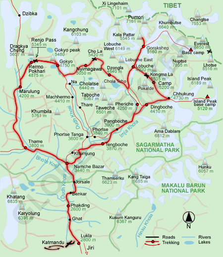
Trekking in the Himalayas has been a dream of mine for a while now, and I figured I came all this way, why not go for the big one – Everest (locally, “Sagarmatha”). The Everest trekking region (on the Nepal side) is called Khumbu. For this post I’ll share the itinerary we followed, approximate costs along the way, random tips, and some photos that honestly just don’t do justice to how beautiful this trek was!

One of the big concerns I had (and this seems to be a common one among young people) – cost. But if you’re willing to carry your own load, and rely on a map and your own good judgement, base camp doesn’t have to break the bank. My plan coming to Kathmandu was to find trekking buddies on the website trekkingpartners.com, and I had been in conversation with a few people on similar schedules and budgets when a friend Sarah, who I’d met Rishikesh at yoga school, messaged me asking if I was still planning on EBC, and if I’d like to buddy up.

We spent a couple days in Kathmandu running errands – buying snacks, warm clothes (we both had mostly hot India weather attire!), renting sleeping bags and down jackets, booking flights to Lukla. And then we were off!

Itinerary:

image

Day 1:

-flight from Kathmandu, 4,593 ft./1,399 m., to Lukla to begin trek
-flight time: about 35 minutes

-start: Lukla, 9,300 ft./2,840 m.
-end: Phakding, 8,562 ft./2,610 m.

-trek time: 3-4 hours
-trek distance: 6.91 mi./11 km*

After both of us were up late into the night packing the night before, we were up at 5am and leaving for the airport at 6. My backpack weighed in at a little over 14 kg (30 lbs.); unfortunately I had all of my snacks out of the bag when it was weighed, which were easily another 7 pounds at least. We flew to Lukla and began trekking around 11am. By noon the rain had started, and we got poured on! We had most of our rain gear, but neither of us had a reliable backpack rain cover, and I discovered midway through our hike that I’d somehow forgotten to pack my rain jacket! We stopped for tea in Thado Koshigaon to try to wait out the rain, but unfortunately it just got heavier! We finally decided to brave it, and arrived in Phakding completely soaked.

Aside from the rain, the hike today was pretty easy, with much of it being downhill.


Day 2:

-start: Phakding, 8,562 ft./2,610 m.
-end: Namche, 11,300 ft./3,440 m.

-trek time: 7 hours
-trek distance: 9.54 mi./15 km.

A much much harder day, but luckily no rain! The hike from Phakding to Monjo (where we stopped for lunch), was a lot of up and down. I was so glad I’d decided to buy trekking poles, as they really helped with the downhill parts especially. After lunch, the trek turned to a pretty relentless uphill climb. We gained over 800 meters today, with significant downhill sections. Needless to say we were hurting by the time we reached Namche!

There is a checkpoint right after Monjo where you officially enter Sagarmatha National Park and must pay another 3,390 rupees.


Day 3:

-acclimation day in Namche

Altitude sickness is a serious concern when trekking at such high attitudes, so we took every suggested precaution to help our bodies cope. Once you pass 10,000 ft./3,048 m. it’s recommended that you ascend no more than 1,000 ft./305 m. per day, and take an acclimation day for every 3,000 ft./915 m. gained. So we took a rest day in Namche, and also began taking Diamox, a medicine that helps prevent altitude sickness. Our timing was near perfect, as that afternoon after taking just the first dose, we both began to feel the dull headache associated with high altitude. Throughout the rest of the trek, I very rarely felt the symptoms of altitude sickness – a little upset stomach or a small headache here and there, but overall I’m convinced that taking Diamox made the acclimation process a lot less painful! It’s worth noting, though, that Diamox can cause a very unnerving tingling in the fingers!

We met fewer people than we expected without guides or porters. The most common response we got from people when we said we’re trekking solo – “you’re so adventurous!” (Judging by the tone, I think a lot of them were thinking “crazy!”)

Day 4:

-start: Namche, 11,300 ft./3,440 m.
-end: Tengboche, 12,700 ft./3,860 m.

-trek time: a little over 5 hours
-trek distance: 8.95 mi./14 km.

The hike out of Namche was about 30 minutes of steep stairs uphill, but the next 2-3 hours were a nice, mostly flat walk along a ridge line. Unfortunately there was a lot of fog today and we couldn’t see much of anything! After stopping for lunch in Phunke Tenga, we crossed a bridge and began our uphill climb. It took about 2.5 hours of constant, pretty steep uphill to reach Tangboche. The climb into Namche was hard, but in my opinion this was harder. It rained on us for only the last 15 minutes or so.

Today was the first day my legs and butt really started screaming at me with each step! And tonight was the first night I felt bone-chilled cold, unable to fall asleep, unable to really warm my toes.

The biggest Buddhist monastery in the Khumbu region is in Tengboche, Dawa Choling.


Day 5 (crossing above the tree line):

-start: Tengboche, 12,700 ft./3,860 m.
-end: Pheriche, 13,900 ft./4,240 m.

-trek time: almost 5 hours
-trek distance: 6.97 mi./11 km.

The trail became a lot less crowded today, and a lot less well marked. The trek from Tengboche to Pangboche (where we stopped for lunch) was fairly easy and relatively flat. The last “big” village you pass is Somare, and then the trail becomes pretty unclear. There is a fork that seems to go three ways, and we stayed to the far left, hiking up a pass that seemed too unmarked to be right. When we finally reached the top and saw Pheriche we were relieved. But when we got the bridge to cross into it, we saw a much clearer trail, the middle fork we assumed, that would have taken us around the side of the hill instead of over it. We made it, but were not the happiest with the mistake we’d made!

No rain today, but another day of pretty heavy fog and poor visibility/few views. We began trekking this morning with lush greenery and trees surrounding us, and ended it with a pretty barren setting; the only living plants this high were hearty, low-profile shrubs.


Day 6:

-acclimation day in Pheriche

We took a short hike today, and were lucky enough for clear (if very windy) conditions. Perfect for the amazing views of Kangtega, Thamserku, Ama Dablam, Island Peak, Nuptse, Lobuche, Cholatse, and Tawoche peaks.


Day 7:

-start: Pheriche, 13,900 ft./4,240 m.
-end: Dughla, 15,200 ft./4,620 m.

-trek time: 2 hours
-trek distance: 3.04 mi./5 km.

Today was one of the easier days. The trail started off flat, and you climb all 300 meters at once, and then cross a bridge into Dughla! The next couple days are short as well; while part of me wanted to keep going, it’s better to be safe and follow the 300 meters per day rule to avoid altitude sickness.

image

Day 8:

-start: Dughla, 15,200 ft./4,620 m.
-end: Lobuche, 16,100 ft./4,910 m.

-trek time: 2 hours
-trek distance: 2.47 mi./4 km.

We woke up to fresh snow on the ground! Although it was melting quickly, and very loudly as it poured off the roofs and onto the ground. The hike out of Dughla was pretty hard, probably an hour or so of straight uphill. Then we came to a small cemetery (I believe it’s only people who have died while attempting to summit Everest but I’m not sure). After that the trek became easier. It was another very foggy day, and there is more than one trail out of Dughla. Throughout the trek we noticed this – one main trail, and others that were usually less pronounced. They seemed to be “shortcuts” (but steeper and more rocky) that Sherpas take. Luckily this trail was very well marked with rock “ducks.”


Day 9:

-start: Lobuche, 16,100 ft./4,910 m.
-end: Gorakshep, 16,900 ft./5,140 m.

-trek time: 3 hours
-trek distance: 3.86 mi./6 km.

One of the side effects of very high altitude is trouble sleeping. I had been feeling this for the last few days, but it reached an all time high last night. I couldn’t fall asleep or stay asleep for long, and when I did my sleep was disturbed with vivid and unpleasant dreams. When the alarm went off at 5:30, I had been wide awake for over an hour.

The trek today was beautiful. The first hour or so was pretty flat, with fresh, powdery snow all along the trail. Then about an hour uphill climb. For the last hour it’s a mix of up and down, up and down. After a particularly large hill, we looked to our right and saw Khumbu glacier! What an amazing sight! Shortly after arriving in Gorakshep it began to snow lightly outside. It was beautiful to watch, but this is exactly why we left so early every morning – so that we could enjoy the rain (and up this high, the snow) from inside!


Day 10 (the BIG day!):

-start/end: Gorakshep, 16,900 ft./5,140 m.
-trek to: Everest Base Camp, 17,600 ft./5,364 m.

-trek time: about 2 hours to B.C., and 1.5 hours back to Gorakshep
-trek distance (total): 5.67 mi./9 km.

The hike to base camp was much easier and shorter than expected. And of course it helped that for the first time, we were able to leave our heavy backpacks behind! After about an hour and a half of moderate ups and downs, we could already see base camp, with numerous groups of tents belonging to summit attempters. On the hike in we passed a few groups that by their matching jackets and wind-burned faces, we could tell had been climbers. One guy we met had made it to the top!

On our way into Base Camp, we saw two avalanches and heard another two! What a site! First the loud clap, like thunder. Then the immense sound a huge waterfall makes as it beats into the water below. And the mass of snow rushing down the mountain in a cloud. One of the highlights of the entire trek!

Base camp is beautifully nestled into Khumbu glacier, and with the sun beating down on it, icicles dripped and glacier rivers flowed. It was unlike anything I’ve ever seen. We walked to the end of the tents, about 30 minutes in, and stopped on a rock to admire the views and enjoy a snack. Once we stopped moving, it was freezing. And soon it began to snow! With the adrenaline and joy of making it to our destination, I didn’t even mind the cold or the snow; I think it made the experience even more spectacular!


Day 11 (the other BIG day):

-start: Gorakshep, 16,900 ft./5,140 m.
-trek to: Kala Patthar, 18,200 ft./5,550 m.
-end: Lobuche, 16,100 ft./4,910 m.

-trek time: Gorakshep to Kala Patthar 2 hours; Kala Patthar back to Gorakshep 1.5 hours; Gorakshep to Lobuche 2 hours
-trek distance (total): 7.55 mi./12 km.

I call this the other big day, because it was our first Everest sighting. Because of the cloudy, foggy days, we hadn’t been able to see Everest from the couple of viewpoints along the trail so far. In addition to being our first viewpoint, Kala Patthar is also the highest elevation we reached. And up that high, every 100 meters made such a huge difference. The hike, 2 hours straight uphill, was probably the hardest for me (even without the backpack!) Breathing was almost impossible, nausea and faintness the entire walk. But we made it! And we were so lucky to have a cloudless sky! From Kala Patthar you can see Everest as well as it’s neighbor Lhotse (the fourth highest in the world, although from this viewpoint it seems to surpass Everest). Trekkers who hiked to Kala Patthar in the days following were unfortunately not as lucky, as the weather was getting worse and worse.

We ate lunch in Gorakshep, packed our bags, and began our descent. The walk back to Lobuche took about 2 hours, and was pretty rocky, and lots of up down up down. But not very hard, and luckily pretty short after the very tough morning hike we had!


Day 12:

-start: Lobuche, 16,100 ft./4,910 m.
-end: Pangboche, 12,900 ft./3,930 m.

-trek time: 5.5 hours
-trek distance: 15.7 mi./25 km.

Since starting our trek, we had been talking about whether or not to go back to Lukla via Chola Pass and Gokyo Lake. It’s supposed to be beautiful, but also hard. The passes go over glaciers, and can be quite slippery. The map warns “crampons recommended” and “stay to the left, crevasse danger.” We were nervous about doing it without a guide, as we’d heard that the trail isn’t well marked in a lot of places. We were also nervous about doing without porters, for fear of slipping on ice with our huge backpacks. We had also heard from guides that it’s safe, but only when the weather is good. And at this point, it had snowed 3 of last 4 days. And we were also tired; my weak knees were getting weaker and weaker. Nonetheless, we wanted to try. So we left Lobuche with the intent of forking to the right to head toward Dzongla and the beginning of the Chola Pass trail. When we reached the fork, the wind was blowing, snow smacking into our faces. It was cold. We actually missed the fork because we couldn’t see very well. Weighing all of the pros and cons, we decided it wasn’t a good idea to head towards a harder trail, alone, at the end of the season (with fewer and fewer trekkers in the area), as monsoon season was just hitting its stride. So we went left, back the way we came. And the universe agreed with us – for about 15 minutes the sun came out, shining on us and left fork; the right fork still dark and covered in fog.

The hike back to Pangboche was a lot of downhill. And the snow never really let up, although it did turn to rain as we descended and the afternoon warmed everything up (even if just slightly).

Day 13:

-sick day in Pangboche

Sarah had unfortunately been feeling the effects of the altitude more than I was. Her stomach caused problems for much of the trek, and she was too weak and tired to trek today after an especially rough night. So we stayed in Pangboche.

Day 14:

-start: Pangboche, 12,900 ft./3,930 m.
-end: Namche, 11,300 ft./3,440 m.

-trek time: a little over 5.5 hours
-trek distance: 11.33 mi./18 km.

The trek from Pangboche to Namche was harder than expected. From Pangboche to Tengboche (where we stopped for lunch) was an uphill climb, and the rest was a constant uphill downhill uphill downhill, ending in the steep steps down into Namche.

image

Day 15:

-start: Namche, 11,300 ft./3,440 m.
-end: Lukla, 9,300 ft./2,840 m.

-trek time: 8 hours
-trek distance: 14.96 mi./24 km.

Today was probably the biggest surprise of the whole trek. All I remembered of the hike from Lukla to Phakding was the rain, and that it was easy. I knew Phakding to Lukla was going to be a lot of downhill at first, then the up down up down that is so hard. But I expected a relatively easy 6 or 7 hour day. I got a very very hard 8 hour day. In the pouring rain. But I was determined to get to Lukla. I was so eager I didn’t even stop for lunch (definitely a mistake in retrospect – never skip a meal!) And around 4:30, soaking wet and pretty miserable, I finally did. I finished the trek! Even after such a long hard day, that felt really good.


Day 16:

-tried (unsuccessfully) to get on a flight back to Kathmandu

Flying into and out of Lukla is notoriously hard. Flights are cancelled all the time if the weather isn’t perfect, and without a guide booking for you, it’s confusing to know for sure if you’re even confirmed for one of the planes that may or may not come. Because of bad weather, flights had been cancelled for 2 days before I arrived in Lukla, so though the skies were clear today, I watched Sita airlines planes come and go, with no seats available.

Day 17:

-flight back to Kathmandu!

I was lucky enough to get on the 2nd flight out of Lukla! Even though I was told to arrive at 7am, I arrived closer to 6:30, and I think being one of the first in line that day really helped in getting me a seat. The flight out was just as beautiful as the flight in, but the excitement I felt coming into Lukla was replaced with a sense of accomplishment, and also a little sadness that I was leaving this beautiful place. But what an experience! It was fun, hard, painful, rewarding, amazing.

The first two things I did as soon as I was back in Kathmandu? 1.) ate 3 bananas 2.) showered – I had zero of both for the last 2 weeks (I have to say bananas were much more missed!)

image

*the trekking distance here was recorded by the Health app on my iPhone, and I can’t guarantee that it was 100% accurate every day!

Costs:

-round-trip flight between Kathmandu and Lukla – $300
-trekking gear in Kathmandu – $175
-rented sleeping bag and down jacket – $1/day – $16
-average daily budget (food and accommodation) – $17/day – $270
-trekking and national park permits – $20 and $33 – $53
-total: about $800
-(the price we heard most frequently for hiring a guide locally was $20/day)

Miscellaneous tips:

-don’t buy used trekking poles in Kathmandu; I did, and saved a few bucks, but one broke halfway through the trek
-tea houses range from free to 200 rupees per night, but you’re expected to take all of your meals there and you’ll be charged if you don’t
-we trekked the last 2 weeks of May, the end of the season as monsoon was coming on; it was cool being there as summitters were coming down, and the trails were not very busy a lot of the time which was nice. I can’t imagine going in the colder months (although that’s apparently when you get the clearest skies), but it would have been ideal to come a few weeks earlier to avoid the rain and snow

Final Thought:

Everest Base Camp is rated as a “moderate” trek, and for most people in decent physical shape this is probably true. The asterisk here is the porter (or in our case, the lack of a porter and the 30+ pound backpack).

On the first day, about 30 minutes out of Lukla, we stopped to use the bathroom. Putting my heavy backpack back on, I somehow ended up crouched on the ground, struggling. An older Sherpa man came over and offered a pole to help me steady myself and stand up. After a pathetic effort, I gave up and took the backpack off. The man asked, “No guide? No porter?…Very difficult, very hard, very problem…”

While we made it, and were that much more proud for having done it alone, I’d adjust this trek to “difficult” for anyone brave enough to carry their own load. There were many, many times I wished I wasn’t. My face in this picture sums it up pretty well – I was really excited, but the struggle was real. Very problem indeed, wise old Sherpa, very problem indeed.

image

family history in mussoorie, india 

A lot of people have asked me why India. The short answer is that I’ve always wanted to come here. The culture fascinates me – the dress, the food, the spirituality – all have always felt so vibrant, so different. The longer, and older answer is that my grandmother and her two brothers were raised in the hills of Mussoorie, India, and it’s always been a sort of pilgrimage/genealogical quest dream of mine to see where she grew up. And I certainly wasn’t the only one to develop a keen interest and strong desire to spend time in India; numerous family members have spent varying amounts of time in the country, and have kept a tie to India strong for all of us. In family gatherings, in culturally influenced bits of decor – I’ve had sprinkles of Indian culture here and there throughout my life. And when I decided to take significant time to travel, there was no question that India was at the top of my list.

Visiting Mussoorie was all about finding the places rich with family history. I started at Woodstock School, an international, English boarding school attended by my grandmother BJ, her two brothers Ray and Dick Smith (all of whom graduated from and spent the majority of their K-12 years there), as well as my mom’s sister, Karen, who spent her junior year of high school there. I scoured yearbooks, toured the school and surrounding area, and even got to stay on campus! My visit coincided perfectly with that of a good friend and classmate of my grandmother’s, Bhavenesh Kumari, who showed me around the school and town, shared meals with me, and most importantly shared stories.

Tucked behind the school is Redwood Cottage, the home my great grandfather built, the house my grandmother grew up in.

I also visited Landour Language School, where my great grandfather, Caldwell Smith worked from (roughly) 1933-71. I met with the current school principal, Chitranjan Datt, whose father worked closely with Caldwell in expanding the Hindi language school. Near the school is the Kellogg Church cemetery, where my great great grandmother Vaughn is buried (no luck finding her, but special nonetheless!)

Mussoorie is now a huge tourism hub for Indians. I spent one afternoon walking around the “main” part of town and was overwhelmed, and a bit turned off by the crowds, the neon signs. There was even a street stall with a guy offering tattoos! So unsanitary!! But the Landour side of town is a total escape from that. It’s quiet and tucked into the hills. It’s quaint. The Sister’s Bazaar and Chaardukan, two main places to visit in Landour, are each just a few storefronts. Landour Bazaar has a special charm, and older feel.

Mussoorie was as a few Indian people had warned me – overly commercialized. But Woodstock school and Landour are in a totally different, beautiful world. This was a very, very special stop for me.

a week in manali

As we were nearing the end of our month long yoga program, I had a general idea of my plans after Rishikesh. I’d stay close to the area, head to Delhi, take a day trip to the Taj Mahal, and then make my way to Nepal by mid-May, at a nice leisurely pace. As soon as I had basically decided this, something else of course tempted me! A handful of my classmates were heading to Manali for a music festival. I LOVE music festivals, and I liked the idea of not saying goodbye.

The day of our graduation, we were packed and ready to go. As soon as we had our certificates in hand and had said our goodbyes, we were off! A group of 10 or so (including a few adopted friends made in Rishikesh) took tuk tuks to the nearest bus stand, made it to our bus with literally no time to spare. Our first bus to Dehradun was an hour and a half – it flew because we were all so excited, not to mention in shock that we’d made the bus!

The next bus was a bit of a different story. It was an overnight local bus. It was packed, uncomfortable, and nearly drove off with at least one of our group at every stop we made. But 15 and a half hours later, we were in Manali, and all of our complaints forgotten. It was beautiful. At about 6am, it was freezing cold (a shock from Rishikesh, where you were always a little on the warm side).

In total, we moved hotels 3 times. We stayed in New Manali where the bus dropped us off the first night. We learned quickly that Old Manali was the backpackers hub, and also the location of the festival. So we moved all together. The festival (Dance of Shiva) was so much fun! A small group of maybe 250 people attended, and by the end of 3 days we knew many of the faces, and lots of names too! The music (psy-trance), was not exactly what I’d choose to play for myself, but it was fun and a new experience! And the festival grounds, a 30 minute walk into the forest, with the main stage backdropped by snow caped mountains – superb.

After the festival, the group of 4 girls left moved to yet another hostel – Rockway- which was tucked into a hillside and about a 10 minute hike from town. A much needed change of pace and scenery from the huge group, the festival, and just the noise that comes with any busy tourist town.

After 9 days in Manali, I was ready to be on my own. My “solo travels” had been anything but so far. It was hard to break from such great friends, and I’ll be surprised if the four of us don’t meet up again soon!

In total it took me about 20 hours (two bus rides, 2 tuk tuk rides, and a taxi ride) to get me back to my next stop, about 30 km from Rishikesh. The route could have been better, but all of the travel was 100% worth it. For the views. For the festival. For the community feeling – we knew so many people by the end of our stay and everyone was always smiling and happy. The restaurant and hotel owners took amazing care of us. If we went to a restaurant for 2 meals in a row, we were pretty much guaranteed free dessert. One day we went to a nearby town, Vashist, and hiked to a beautiful waterfall with amazing views of the entire valley.

There was so much in Manali that I would have loved to stay longer for – more hiking and trekking, temples, more waterfalls. But until next time, I will remember my week there very fondly.

yoga teacher training in india – expectations vs reality

Almost two weeks ago I completed a 200 hour yoga teacher training certification with Nada Yoga School in Rishikesh. Now that I’ve had some time to decompress, here are some thoughts.

Expectations (although, I honestly tried to have as few as possible):
-super healthy vegan diet

-no alcohol, caffeine, or sweets

-several hours of intense physical yoga per day

-a diverse group of people from all over the world

-somewhat “western” accommodations (hot water, wifi, etc.)

-long days, and mental and physical exhaustion

Reality:
-white rice, heavy soups and cooked dishes (vegetarian, not vegan)

-no caffeine

-no alcohol anywhere in Rishikesh (ok, actually I have heard of one place)

-lots of sweets

-several hours of very technical physical yoga per day (alignment alignment alignment!)

-a diverse group of mostly women from all over the world (but a lot of us from the states and Canada)

-no hot water

-squat toilet

-no wifi in our rooms (just at the school and cafes)

-yoga philosophy classes with an extremely knowledgable, but very eastern-style guru

-meditation classes that are hard to follow sometimes, and minimal instruction around whether or not I’m “doing it right”

-long days, and mental and physical exhaustion

My overall thoughts: 

I did feel myself getting stronger, physically but also mentally. I did poses I’ve never even attempted. I meditated 30 minutes or more every day (from 0 ever before). I learned a lot about the history and philosophy behind a practice that encompasses body mind and soul – a huge shift in understanding about something a month ago I was doing purely for physical exercise.

We did major detoxing. In week 1 when I was one of the first students to successfully do jala neti from mouth to nose I was proud! I couldn’t have predicted that less than 2 weeks later I’d be proud of myself for doing shankprakshalana (going to make everyone google that one…)

Teacher training is intense. From what I’ve heard, that’s universal. Whether you do it in San Francisco or Rishikesh, it’s unlike anything you could have imagined. Bonus points for an AMAZING group of people, many of whom I’ve already traveled with and more still I plan to meet up with further into my trip!